![]()
![]()
![]()
![]()
![]()
![]()
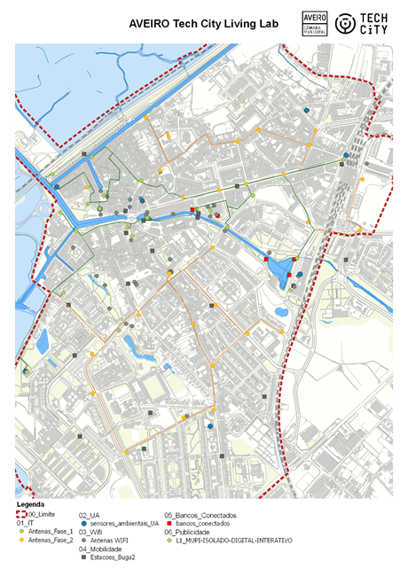
In this context, the following map shows the territorial coverage of ATCLL, including a set of municipal devices, equipment and facilities capable of meeting the experimentation needs of new technological projects:
The following components are available in phased form in the ATCLL constitution:
· Equipment
· Communications infrastructure
· Space for presentation and experimentation
· Urban platform
In the following chapters the four components listed above are characterised in detail.
A. Equipment
ATCLL includes a set of equipment installed in the urban centre, which assume a set of monitoring or user interaction functions. Some examples are the following equipment:
· Environmental sensors
· Mobility sensors (GPS, Lidars and Radars)
· Connected banks (with environmental monitoring)
· Mobility sensors on bicycles (accelerometer / brake light)
· Bike-sharing stations [to be installed by May 2021]
· Wi-Fi Antennas
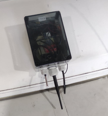
There are also mobile sensor equipment installed in public transport or rubbish collection vehicles, which currently record the following parameters:
· Location and direction;
· Speed;
· Temperature;
· Noise level.
Regarding the mobile sensors and vehicular communication elements, they are represented in Pictures 2 and 3, respectively, excluding the antennas.
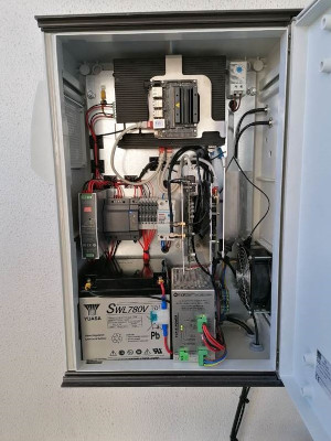
B. Communications infrastructure
1. Composition
The communications infrastructure integrates a communication network with radio terminals, multiprotocol, spread throughout the city, connected by fibre optics to a data processing centre (located at the Institute of Telecommunications). This network is complemented by mobile and fixed sensor equipment and mobile communication equipment installed in vehicles or carried by ATCLL users. In short, the infrastructure includes:
· On its access aspect:
o 16 km of fibre optic;
o Wi-Fi access points;
o Road Side Units;
o Edge Computing Units;
o LoRa Gateways;
o LoRaWAN compatible Gateways;
o 4G/5G Access Points (SDR based);
o Spectral probes;
· On its central equipment aspect:
o Datacenter;
o Switches SDN with optical interfaces;
o Servers;
o Network monitoring and management system;
o Data platform;
o 4G/5G Core;
· On its mobile equipment aspect:
o Sensor units with LoRa communication (LoRaWAN compatible if necessary);
o WiFi and vehicular communication units (WAVE), which can be upgraded to C-V2X, with the possibility of including 5G CPEs;
o 5G terminals.
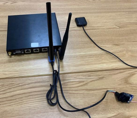
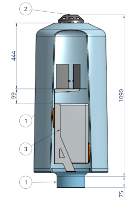
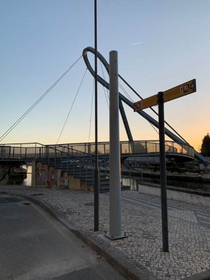
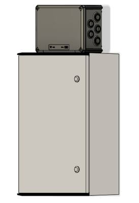
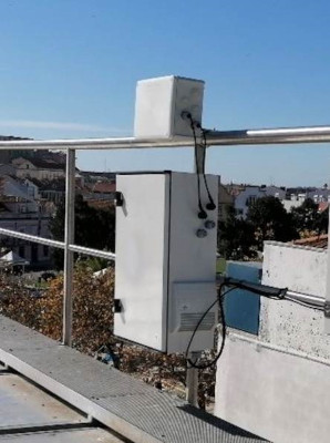
The radio access points are distributed throughout the city of Aveiro according to two fixing structures: on vertical poles or on building façades. Picture 4 illustrates, excluding the antennas, the composition and distribution of the various equipment on the vertical pole slope. Picture 5 shows the distribution of the equipment in a box to be placed on the façade. In both solutions, space and power required for placing new equipment has been reserved, which makes the infrastructure flexible and in constant evolution.
2 - Distribuição geográfica
A infraestrutura de comunicações está instalada na área urbana da cidade de Aveiro, sendo a sua cobertura rádio dependente da tecnologia de comunicação a utilizar. Pela cidade, e conforme ilustrado na Figura 6, estão colocados 43 pontos de acesso rádio, 27 em suportes metálicos verticais, e 16 em fachadas de edifícios. Os componentes de rádio não são idênticos em todos os pontos de acesso rádio, sendo limitada a presença de acessos 4G/5G baseados em SDR a 24 pontos.
MAPA
Figura 6 - Localização dos pontos de acesso rádio da Infraestrutura de comunicações.
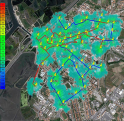
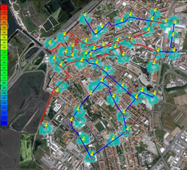
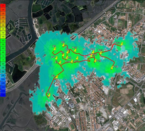
3. Communications Infrastructure Coverage
The communications infrastructure has a radio coverage that depends, among others, on the communication technology to be used. Preliminary studies, represented in Pictures 7, 8, 9 and 10, present the network coverage diagrams, based on simulation for the frequencies 2.4GHz, 5.9GHz, and SDR at 1GHz and 2GHz respectively. The last two cases are only guaranteed at some points of the network.
4. Characterization of the 5G Network
The communications infrastructure also includes a 5G network composed of 5G antennas connected to a 5G core managed by Altice Labs. These infrastructures are connected to the data collection and processing platform and analytic also managed by Altice Labs.
C. Space for experimentation
Aveiro Tech City Living Lab has in the Atlas Aveiro Building a multifunctional space intended for experimentation on territory data, as well as on the dynamism of the Aveiro Municipality, showing an evolution of the social, economic and industrial development, the employment generated, and the innovative and exporting character of the Aveiro companies. In addition to access and exploitation of data in the various equipment available, an auditorium is available which will have an annual activity plan, with the direct involvement of different audiences. Through previous analysis and validation, this auditorium may be used by companies who wish to present the work developed at Aveiro Tech City Living Lab.
D. Characterization of the Urban Platform for Data Management and Analysis
The urban platform will allow the processing and analysis of data and the sharing of information from various sources, providing analytical and predictive services for IoT applications and vertical applications for the city.
The urban platform is composed of a component of integration, aggregation and processing of data from various sources of information, namely:
· Electricity consumption
· Statistics and performance of the experimental communications network
· Rubbish collection
· Environmental sensors in the territory
· Vehicular units
· Mobility
· Municipal activity and performance according to ISO 37120 standard
· Gas and water consumption
· Other sources of sensor information in the city
The data integration component also has the capacity to manage API's, allowing the creation of API's for dissemination of specific information datasets according to the needs of each project or experimental activity.
The urban platform also includes a visualisation and data mining component, called the city governance centre. This component provides access to various sources of information, in tabular, graphic and geographic format, allowing an analysis and correlation of data. Access to this data access interface can be made available for experimental projects in the territory.

All rights reserved © Aveiro Tech City / Câmara Municipal de Aveiro

